Historical Remnants on the beach at Emma Wood State Park


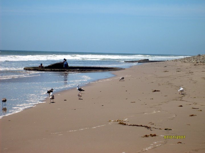
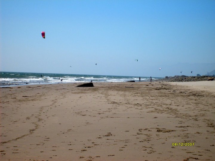
Walking on the beach at Emma Wood State Beach, one comes across two concrete pillars, maybe surrounded by 38 foot concrete rings (depending on the season and the tides) 250 feet apart. What are they?

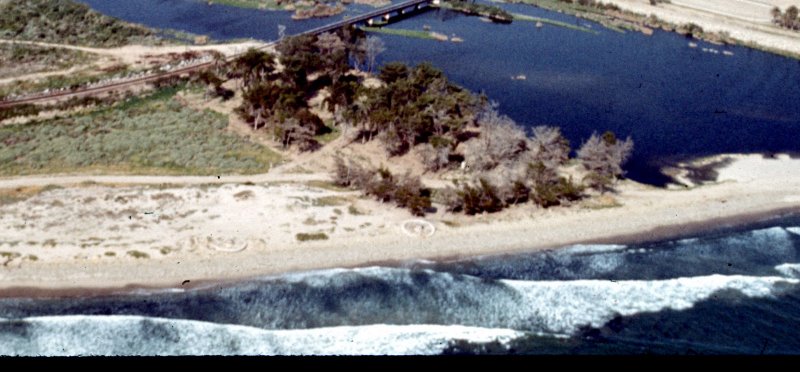
Rings are visible

Rings hidden by sand


There is only a small reference to these structures in the Emma Wood State Beach web page "The park also features the crumbling ruins of a World War II coastal artillery site," with no other references about what, where, why and how.


Where are these remnants? The next photo shows them back in 1972, when the center support was actually in the center.


1972 Overview -- See the two rings at the bottom of picture, well above the beach ....
Copyright (C) 2002-2007 Kenneth & Gabrielle Adelman, California Coastal Records Project,
www.Californiacoastline.org


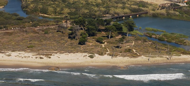
In this photo, from 2002, the ocean has eroded more of the beach,
and the center support is no longer centered.


2002 Overview -- See the two rings at the bottom of picture, in the surf line....
Copyright (C) 2002-2007 Kenneth & Gabrielle Adelman, California Coastal Records Project,
www.Californiacoastline.org

Panama Mount
What is a Panama mount?


More current photos
Here is a link to more photos of the gun emplacements taken during June to August, 2007


The shelling of Ellwood
Here is a story providing more details about the initial shelling of the California coast (referenced in the brochure below), which provided the stimulus to build the coastal defenses.


Some of the history and details of these structures are described in a brochure from the Californa State Parks and Recreation, which is reproduced below. Also, if you find this site interesting, or you have any comments, please sign the guest book.
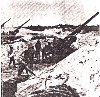


View My Guestbook
Sign My Guestbook


The Guns of Ventura©

The story of Ventura’s World War II Coastal Artillery Battery


Photo of gun emplacement with men


On a windswept cobble beach near the mouth of the Ventura River, two large concrete rings, each 38 feet in diameter, stand as mute reminders of a time when soldiers came to this place with their machines of war. Here for a brief time during World War II, the U.S. Army established a coastal defense battery. Here a pair of huge cannons sat atop the concrete rings, and the GIs warily scanned the watery horizon for the first sign of invasion or attack. This is the story of Battery Two … of the not-too-distant past when WAR came to Ventura!


West Coast Attacked!


Fear gripped 
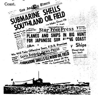
Americans on the West Coast following the devastating surprise attack by the Japanese at Pearl Harbor. This fear was not groundless: large cities lay along the coast, miles of beaches invited the landing of troops, and West Coast residents were receiving almost daily reports of the continuing conquest of the Pacific by Japanese forces. Existing coastal defenses were located only at major harbor entrances, leaving the rest of the coast exposed and vulnerable.

In late December, 1941, a number of long-range Japanese submarines reached the California coast and sank or damaged several merchant ships. War jitters increased in January, 1942, as rumors of imminent attacks by phantom warships were received.

In the evening twilight of Monday, February 23, 1942, the Japanese submarine “I-17” surfaced 
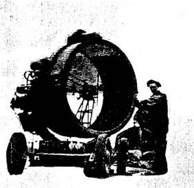
offshore from the Ellwood oilfield, 12 miles north of Santa Barbara, and opened fire with its 5.5” deck gun on the oil wells and storage tanks there. Although the damage inflicted was slight, this was the first attack of the war on the continental U.S., and it renewed fear in Americans living along the Pacific Coast


Photo of period newspapers


Coastal Defense Set Up


Photo of searchlight


Immediately after this attack, the 2nd Battalion of the 144th Field Artillery (California National Guard) was rushed from Fort McArthur near Los Angeles to set up artillery batteries along the Santa Barbara coast. One such battery was established near the mouth of the Ventura River where two 155 mm cannons were hastily set up on the beach (the rich Ventura Avenue oilfields lay just up-river). In what had been a city park nearby, soldiers set up a small tent camp in the camouflage and shelter of a grove of cypress trees. They positioned a mobile searchlight to illuminate targets at sea, and prepared for the worst.

By October 1942, the Japanese forces were on the defensive, but the threat of attack along the U.S. coast had not been eliminated. The 56th Coast Artillery Regiment arrived in Southern California from Fort Cronkhite near San Francisco to relieve the National Guard Field Artillery units where were transferred overseas.

At what is now the 
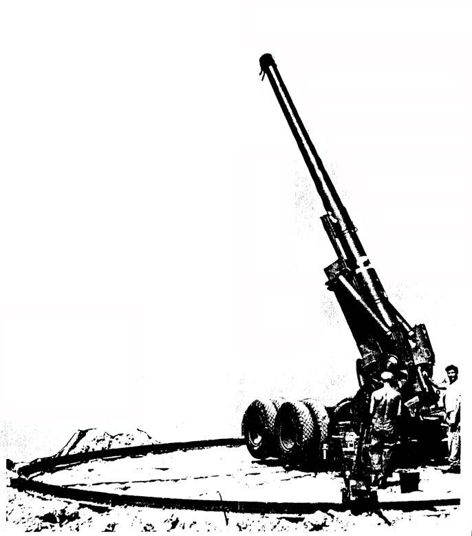
Ventura County Fairgrounds the Regiment set up Camp Seaside, command post for all the artillery batteries and searchlight units between Point Mugu and Santa Barbara.


“Long Toms” Arrive


In contrast to the World-War-I vintage guns used earlier, the 56th Regiment was equipped with the much improved “Long Tom” guns which could fire a 95 –pound projectile 14 miles! The accurate firing of these large guns required careful coordination. Spotters at two separate observation posts
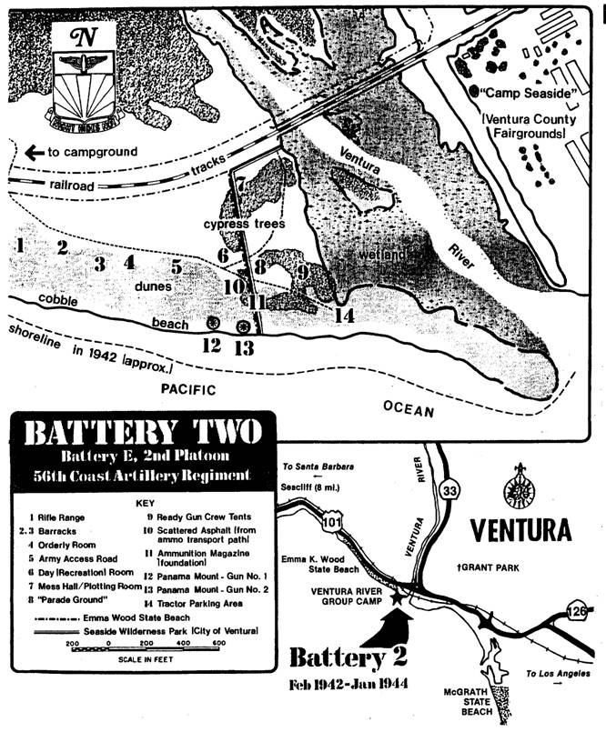
 (one at Grant park above Ventura, the other a few miles north on the bluffs above Seacliff) took bearings on the target and relayed this information via field telephones to the battery plotting room near the guns. Plotters then calculated the target’s location and sent aiming instructions to the gun crews who brought the guns to bear and commenced firing! Twice a day the soldiers would practice “dry firing” the Long Toms, and once a month they fired live ammunition at targets towed offshore. The GIs also participated in “war games” by turning the guns to point inland and simulating a counterattack again enemy troops which were occupying Ventura and the surrounding hills (the full-circle iron rails of the Panama Mounts were designed to permit turning the guns to fire inland in such a situation).


Photo of Long Tom, with crew on a Kelly 
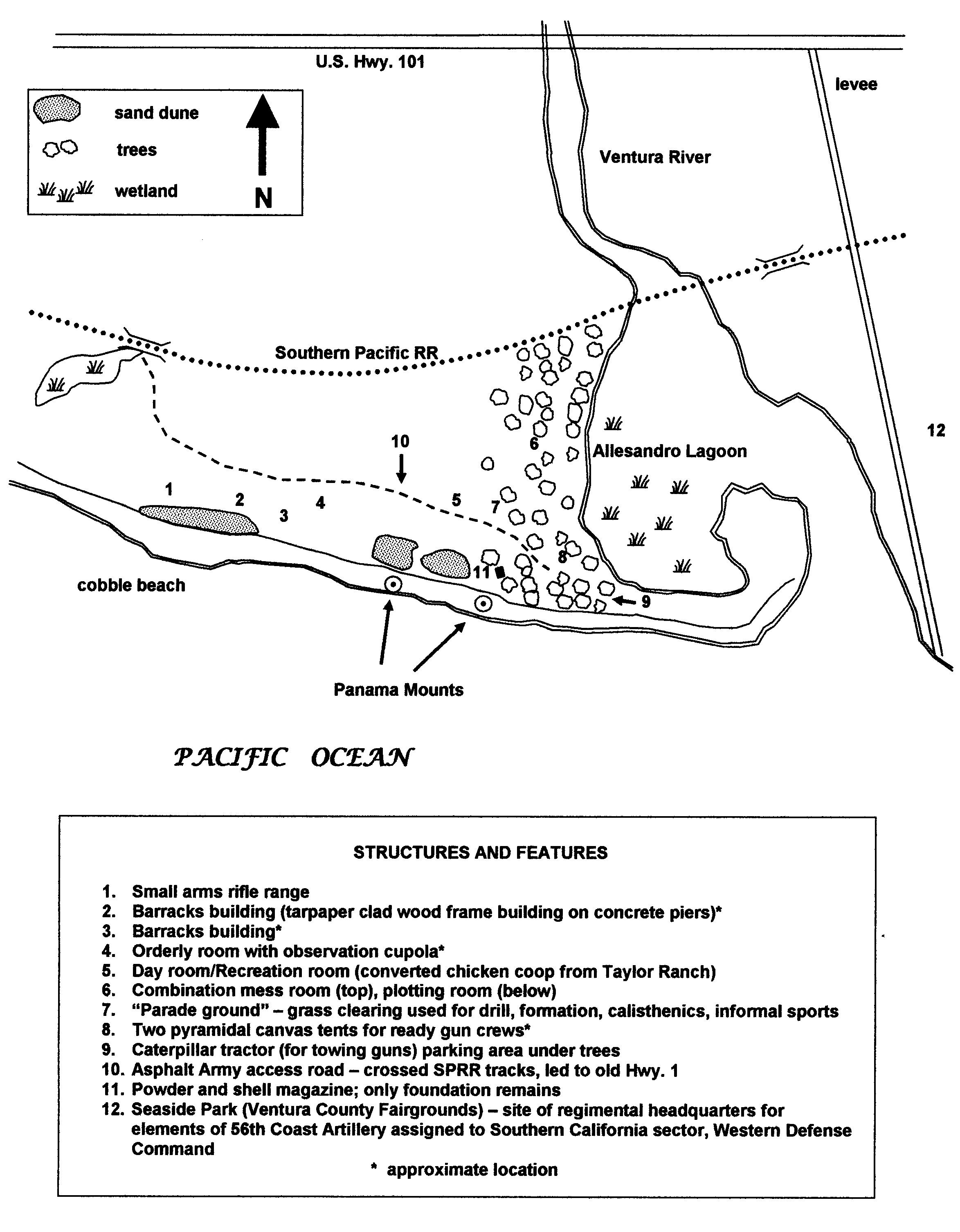
base (it looks like)


GIs Dig In


The GIs quickly made Battery 2 more permanent. To provide stable platforms and allow rapid turning of the big guns they built two concrete “Panama mount” gun emplacements (first used along the Panama Canal). They laid asphalt roads and walkways over the sand, and under the cypress trees they built barracks and other wood-frame-and-tarpaper buildings, as well as a small ammunition magazine (see map). The soldiers of Battery 2 trained continuously in order to maintain a high degree of readiness. A typical day included calisthenics, rifle range practice, and drill on an improved “parade ground”. The soldiers even helped the local community: they fought fires, built fire breaks, and picked fruit on nearby ranches.


Map of Battery Two Site


More precise map of Battery Two Site


Prologue (should be Epilogue)


By January, 1944, the threat of enemy attack to the west Coast was gone and Ventura’s Battery 2 was deactivated. The big guns and the soldiers who operated them were shipped to the distant combat zones across the Pacific. The buildings were dismantled and the site was abandoned. Today all that remains are the two Panama mounts, the foundation of the ammunition magazine, and a few pieces of the asphalt road. Of the ten artillery sites built by the Army to protect the Southern California coast, only three, including Battery near Ventura, still survive. Never test in combat, Battery 2 is today losing a different battle to the relentless attack of erosion, wind, rust and vandals.

Still it is possible to stand on this site and imagine those early days of World War II when the future held so much fear and uncertainty for Americans, and when the GIs of Ventura’s Battery 2 stood ready to defend America from attack …


PRESERVE YOUR HERITAGE!

This historic site is protected within the boundaries of Emma
Wood State Beach and Seaside Wilderness Park. The
California Department of Parks and Recreation and the City of
Ventura remind you that this and all other historic sites are a
valuable part of your heritage and are protected by state and
federal law. Please do not remove or disturb any artifacts.
Reports acts of vandalism to a Park Ranger or Camp host.


The California Department of Parks and Recreation gratefully acknowledges the invaluable contribution of Mr. Jason Marmor for his research of Battery 2 and for his assistance in the production of this brochure.


Funding for this 
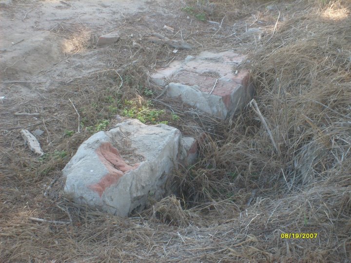
brochure provided by the CHANNEL COAST NATURAL HISTORY ASSOCIATION. All rights reserved.

Photos from National Archives.


Last updated 9 February 2008
Comments about web page format
should be sent to Don


Using the above map, I walked the area. I did not see any scattered asphalt, but I did see some bricks and concrete in the ground. At first I thought it could be the foundation of the ammunition magazine (referenced as item 11 in the above map), but Jason Marmor corrected my assumption -- it's in the wrong place, and it's not what the foundation looks like. But here's a photo anyhow:


Try using the Open Directory Project to search for other stuff. 
It uses human editors to intelligently add to their data base of web sites.


dmoz.org